The best scenic drive in central Crete
A compact loop of about 110 km from Rethymno, with two gorges you drive straight through: via the springs of Argyroupoli and the Kotsifou gorge to the bay of Plakias, past Preveli monastery above the famous palm beach, back up through the Kourtaliotiko gorge and past the lion fountain of Spili to the sea again. For a rental car, convertible or motorbike.
For Garmin, Komoot or TomTom: download the GPX.
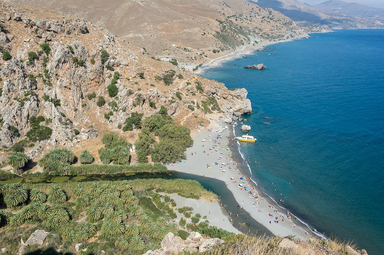


Photos via Wikimedia Commons: Preveli by Uoaei1 (CC BY-SA 4.0), Plakias by Uoaei1 (CC BY-SA 4.0), Argyroupoli by Dietmar Rabich (CC BY-SA 4.0).
Two gorges, a palm beach and a lion fountain
Central Crete, the country around Rethymno, is Crete in miniature: springs under plane trees, two gorges the road squeezes through, a monastery high above the Libyan Sea and a palm beach that could exist nowhere else in Europe. This drive strings it all onto a compact loop of about 110 kilometres, from the north coast straight through the mountains to the south coast and back.
The gorge roads are the point: first the road threads the Kotsifou gorge, where a chapel shelters under an overhanging wall of rock. And on the way back you drive straight through the Kourtaliotiko gorge, its cliffs patrolled by vultures, a forty-metre waterfall in its depths and a wind that, so the Cretans say, claps its hands in the caves. In between lie the bay of Plakias and the monastery of Preveli, which in the Second World War helped Allied soldiers escape to submarines from the beach below.
Unique to Touren.app: you do not have to start in Rethymno. Click "drive it as a loop from your location" and we rotate the loop so it starts at the point nearest your hotel or apartment and brings you back there.
The route on the map
A schematic overview by Touren.app, not a navigation map. The exact route opens under “Drive this route” or in Google Maps. Map orientation: north is up.
Plan your own route
The 7 places along the route

1. Rethymnon
After Chania, Rethymno has Crete's loveliest old town: a tiny Venetian harbour basin with a lighthouse, minarets above the rooftops and the broad Fortezza fortress on the hill. Walk a lap of the little harbour before you set off, or save the town for the golden evening light after the drive.
Practical: park along the seafront or by the Fortezza; the old town itself is largely car-free. This is stop 1 and the pivot point of the drive-from-your-location loop.
2. Argyroupoli (bronnen)
Argyroupoli stands on the remains of the ancient city of Lappa, but its fame is its springs: at the foot of the village, mountain water tumbles year-round over moss-green cascades, between plane trees and old washing places. The tavernas set their tables right beside the running water, trout on the menu.
Practical: park by the springs below the village. Come in the morning for the quiet; up in the village the top terrace earns its view over the valley.

3. Kotsifou-kloof
Beyond Kanevos the road to Plakias squeezes through the Kotsifou gorge: walls hundreds of metres high that close in until you wind down the window just to look up. Against the rock, half beneath an overhang, shelters the little chapel of Agios Nikolaos, proof that Cretans will truly build anywhere.
Practical: there is a small lay-by at the chapel for the photo. Drive gently: the gorge road is narrow and traffic comes the other way.
4. Plakias
The gorge releases you above an amphitheatre of olive groves running down to Plakias, a relaxed resort on a wide bay with mountains on three sides. The long beach, the seafront tavernas and the southern sun make this the natural coffee or lunch stop of the loop.
Practical: parking along the seafront is usually easy to find. Staying longer? The sunset drops straight into the bay here.
5. Moni Preveli & palmstrand
On a balcony above the Libyan Sea lies Moni Preveli, the monastery that hid Allied soldiers in 1941 and helped them escape to submarines from the beach below; the monument with the rifles remembers it. Down there the Megalopotamos river meets the sea through a forest of Cretan date palms: the famous palm beach, which grew back completely after the 2010 fire.
Practical: the monastery asks for covered shoulders and knees. For the beach, park at the cliff car park and take the steep stairs down (allow twenty minutes back up), or ride a small boat from Plakias.

6. Kourtaliotiko-kloof
Heading north again you drive straight through the Kourtaliotiko gorge, the bigger of the two: cliffs where bearded vultures hang on the thermals, a forty-metre waterfall in the depths and a name that comes from "kourtala", the hand-clapping sound the wind makes in its caves. Halfway through, another chapel of Agios Nikolaos shelters by the road, with steps down towards the waterfalls.
Practical: lay-bys along the gorge road; the steps down are steep but worth it. Look up for the vultures.

7. Spili
Spili is a cool mountain village at 430 metres, built around a Venetian fountain where mountain water pours from a row of 25 stone lion heads, ice-cold and drinkable. Fill your bottle, take a Greek coffee under the plane trees, then roll the half hour back to Rethymno.
Practical: park along the through road and walk into the car-free square. The fountain runs all year; the water comes straight off the mountain.
Practical: for a rental car, convertible or motorbike
From which town: the route starts at Rethymno, but you do not have to begin there. Click "drive it as a loop from your location" and Touren.app rotates the loop to the point nearest your hotel or apartment. From Plakias or Spili the loop works just as well; from Chania or Heraklion you reach it along the north coast.
Gorge roads: both gorges carry ordinary paved through-roads, but they are narrow with blind bends. Drive gently, use your horn where you cannot see and expect goats. In a convertible you want the roof open here: the walls tower hundreds of metres above you.
Combining beach and monastery: the stairs to Preveli palm beach are steep (allow twenty minutes back up) and shade is scarce outside the palm grove. Wearing flip-flops? Take the little boat from Plakias instead.
Fuel and tolls: fill up in Rethymno or Spili; between Plakias and Preveli there is nothing. Crete has no tolls anywhere (as of 2026) and this loop never even touches the national road.
Best time: the south coast is almost always a few degrees warmer and drier than the north coast. In spring the gorge rims bloom; in summer the springs of Argyroupoli and the fountain of Spili are built-in cooling.
Reviews from drivers
Reviews appear here with vehicle, experience and month of the drive. A score cannot be bought here, and this stays empty until someone has really driven it.
Share this route or save it
Share this drive with whoever should drive it
Or email it to yourself, for the road
Email this route to yourselfFrequently asked questions
How long is the best scenic drive in central Crete?
About 110 kilometres, with some 2 hours 50 minutes of pure driving, measured via a route planner. With the stops it is a generous half day to a full day; add beach time at Preveli or Plakias and it fills a holiday day beautifully.
Can I drive the route from my own hotel or apartment?
Yes: click "drive it as a loop from your location" and Touren.app rotates the loop so it starts at the nearest point and ends back at yours. Staying in Plakias? Then the drive simply starts there.
Are the gorge roads suitable for an ordinary rental car?
Yes. Both the Kotsifou and the Kourtaliotiko gorge carry ordinary paved through-roads. They are narrow and winding though: drive gently, sound your horn on blind bends and expect goats on the tarmac.
How do you reach Preveli palm beach?
Park at the cliff car park beyond the monastery and take the steep stairs down to the beach; the climb back takes about twenty minutes. Rather not climb? In season, small boats run to the beach from Plakias.
Can you do this drive from Chania or Heraklion?
Yes, but allow serious extra driving along the north coast (a good hour each way from either city). The loop itself stays the same; the drive-from-your-location button pins it to your side.
What does the name Kourtaliotiko actually mean?
It comes from "kourtala", Cretan for the sound of clapping hands: in a stiff wind the air makes that sound in the caves high in the gorge walls. You hear it best at the lay-bys just after the northern entrance.
Are the exports really free?
Yes, free with a Touren.app credit on them. You never pay us for exports.
Keep exploring
Fancy this drive, but from your own holiday address?
Click "drive it as a loop from your location" and Touren.app rebuilds the same loop from your hotel or apartment, and brings you back to it.
Generate your version of this route