The most beautiful drive on Tenerife
A 186 km loop through the Teide National Park and along the north coast of Tenerife, past the eight finest places: from the volcano Mount Teide (the highest point in Spain) and the Roques de García to the mountain village of Masca, the lava coast of Garachico and the thousand-year-old dragon tree of Icod. For the rental car, convertible or motorbike.
For Garmin, Komoot or TomTom: download the GPX.


Photos via Wikimedia Commons: Mount Teide by H. Zell (CC BY-SA 3.0), Roques de García by Puusterke (CC BY-SA 4.0), Masca by Marc Ryckaert (CC BY-SA 4.0).
From sea level up to the volcano and back
Tenerife is an island of extremes: at its centre rises Mount Teide, at 3,715 metres the highest mountain in Spain and one of the tallest volcanoes on Earth, ringed by a moonscape of lava. Around it lie pine forests, vineyards, black lava beaches and green villages. This drive strings together the eight finest places in a single loop of 186 kilometres, from the colonial town of La Orotava up into the national park and back along the north coast.
Unique to Touren.app: you need not start in La Orotava. Tap "Drive this route from your location" and we rotate the loop so it starts at the point nearest your hotel or apartment and brings you back. Everyone drives the same beautiful route, but from their own front door.
The route on the map
A schematic overview by Touren.app, not a navigation map. The exact route opens under “Drive this route” or in Google Maps. Map orientation: north is up.
Plan your own route
The 8 places along the route

1. La Orotava
La Orotava sits at about 400 metres in the green Orotava valley, with a pristine historic centre from the 16th and 17th centuries. The Casa de los Balcones shows the famous carved Canarian wooden balconies; at Corpus Christi the townspeople cover whole streets with carpets of flowers. A fine prelude before you head into the national park.
Practical: park on the edge and walk the steep lanes of the old centre.
2. El Teide (Teleférico)
The TF-21 climbs through pine forest into the Teide National Park, a UNESCO World Heritage Site since 2007. Mount Teide itself is, at 3,715 metres, the highest point in Spain; a cable car takes you from 2,356 to 3,555 metres. The final metres to the summit may only be walked with a free permit booked in advance, so you cannot drive to the top.
Practical: park at the cable-car base station; it does not run in high wind. Bring warm clothing, it is cold at the top.
3. Roques de García
At the Mirador de La Ruleta, opposite the parador, stand the Roques de García: strangely eroded rock formations on the rim of the old caldera, with the famous Roque Cinchado (the "stone tree") and Mount Teide behind. Below stretches the Llano de Ucanca plain, at some 2,150 metres. The best-known view on the island.
Practical: a drive-to viewpoint with car park; a 3.5 km circular walk leads among the rocks (no permit needed).
4. Masca
On the western side, in the ancient Teno massif, lies Masca: a tiny village at some 650 metres, high above a deep gorge, for a long time reachable only on foot. The road there, the TF-436, is one of the narrowest and twistiest on the island. The village itself is free to visit; the gorge hike down to the sea needs a permit booked in advance.
Practical: the TF-436 is narrow with many hairpins, take it steady; parking is limited. The gorge hike is permit-only (a limited number per day).

5. Garachico
Garachico was once the island's main port, until a lava flow in 1706 largely buried it and reshaped the coastline. What the lava left are El Caletón, natural pools in the black rock, and a beautifully rebuilt little town. From the mirador above town you look down on the whole scene.
Practical: park by the centre and walk to the lava pools; swimming is possible when the sea is calm.

6. Icod de los Vinos
In Icod de los Vinos stands the Drago Milenario, the largest and oldest known dragon tree (Dracaena draco), some 20 metres tall and a national monument since 1917. The tree is the symbol of Tenerife; its exact age is guessed at, but it is centuries old at least. Around it lie vineyards on volcanic soil.
Practical: you see the tree for free from the church square; up close via the paid Parque del Drago.

7. Mirador de El Lance
On the way back towards the coast, near Los Realejos, lies the Mirador de El Lance, a roadside viewpoint that looks out over the whole Orotava valley, from La Orotava and Puerto de la Cruz up to Mount Teide. By the viewpoint stands the monument to the leap of the Guanche king Bentor. A stop to take in the island at a glance.
Practical: a drive-to viewpoint with parking along the road; no walking needed.
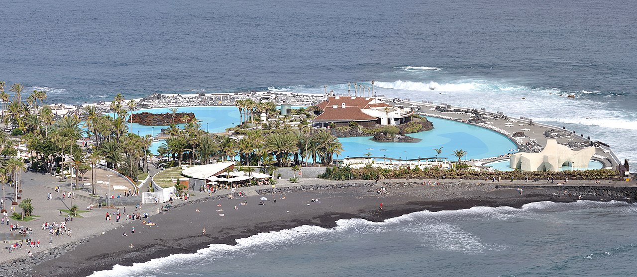
8. Puerto de la Cruz
Puerto de la Cruz closes the loop: the island's oldest resort on the north coast, with the black-sand Playa Jardín and the Lago Martiánez, a seawater lido designed by the artist César Manrique. A fine place for a last walk by the sea before you drive back to La Orotava in a quarter of an hour.
Practical: car parks in the centre; a short, flat drive back to La Orotava to close the loop.
Practical: for the rental car, convertible and motorbike
From which place: the route starts in La Orotava, but you need not start there. Tap "Drive this route from your location" and Touren.app rotates the loop to the point nearest your hotel or apartment, so you set off from your own front door and return to it.
For which vehicle: the mountain roads of Tenerife are a joy in a rental car, convertible or on a motorbike, but allow for a big change in altitude: from sea level to 2,356 metres at the cable car. The TF-436 to Masca is narrow and twisting; long motorhomes should skip that detour.
Best time: Tenerife is mild year-round, but up in the park it is cool and sometimes snowy. Set off early for the park; the cable car closes in high wind. The summit of Mount Teide needs a free permit booked well in advance.
Respect nature: the Teide National Park is World Heritage. Stay on the roads and paths, take your litter with you and park only in the proper places.
Reviews from drivers
Reviews appear here with vehicle, experience and month of the drive. A score cannot be bought here, and this stays empty until someone has really driven it.
Share this route or save it
Share this drive with whoever should drive it
Or email it to yourself, for the road
Email this route to yourselfFrequently asked questions
How long is the most beautiful drive on Tenerife?
About 186 kilometres, with around 4 hours and 41 minutes of pure driving, measured via Google Maps. With the national park, the coast and the stops it is a full, beautiful day.
Can I drive the route from my own hotel?
Yes, and that is the unique part: tap "Drive this route from your location" and Touren.app rotates the loop so it starts at the nearest point and ends back at you. So you need not go to La Orotava first.
Can I drive up Mount Teide?
You can drive to and park at the cable-car base station at 2,356 metres. The cable car takes you to 3,555 metres; the final metres to the true summit (3,715 metres) may only be walked with a free permit booked in advance.
Is the route suitable for a rental car?
Yes. All of it is paved road. The TF-21 and TF-436 have many bends and a big change in altitude, so take it steady and check your brakes on the descent.
Are the exports really free?
Yes, free with a Touren.app credit on them. You never pay us for exports.
Keep exploring
Fancy this volcano drive, but from your holiday address?
Tap "Drive this route from your location" and Touren.app rebuilds the same island loop from your hotel or apartment, and brings you back.
Generate your version of this route