The most beautiful drive on São Miguel (Azores)
A loop of about 150 km around São Miguel, the green main island of the Azores, past the six finest places: from the capital Ponta Delgada to the twin crater lakes of Sete Cidades, the north-coast town of Ribeira Grande, the Gorreana tea plantation, the hot springs of Furnas and the crater lake of Lagoa do Fogo. For the rental car, convertible or motorbike.
Plan for: a full day; the winding mountain roads make 150 km a real day trip
Drive this route from your locationOpen in Google MapsFREE Download GPXFREEFor Garmin, Komoot or TomTom: download the GPX.


Photos via Wikimedia Commons: Gonçalo Torres (CC BY-SA 4.0), The Cosmonaut (CC BY-SA 4.0), Diego Delso (CC BY-SA 4.0). Usable commercially, with attribution.
Crater lakes, hot springs and tea fields in the middle of the ocean
São Miguel is the green main island of the Azores, a volcanic world in the middle of the Atlantic: craters with twin lakes, a landscape of hydrangeas and cow pastures, valleys where the water boils and steams, and the only tea plantations in Europe. This loop of about 150 kilometres threads together the six finest places, from the capital past the great craters and the warm valley of Furnas.
Unique to Touren.app: you do not have to start in Ponta Delgada. Tap "drive this as a loop from your location" and we spin the round so it begins at the point nearest your hotel and returns you there, whether you are in Ponta Delgada, Ribeira Grande or Furnas.
The route on the map
A schematic overview by Touren.app, not a navigation map. The exact route opens under “Drive this route” or in Google Maps. Map orientation: north is up.
Plan your own route
The 6 places along the drive
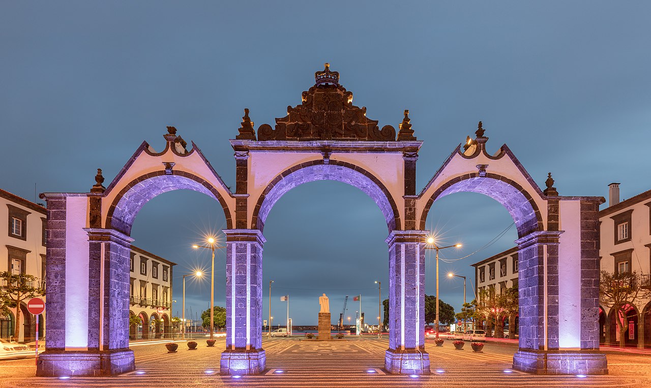
1. Ponta Delgada
Ponta Delgada is the capital of the Azores, a harbour city of black-and-white facades in basalt and limestone, with the three arches of the Portas da Cidade as its most famous image. Behind the seafront lie cobbled streets, churches and the marina from which the whale-watching trips leave; it is the lively start and end of the loop.
Practical: park by the marina and walk to the Portas da Cidade and the centre. This is where you pick up the rental car (PDL airport is nearby). From this point Touren.app also spins the loop from your own hotel.
2. Sete Cidades
Sete Cidades is the most famous image of the Azores: a giant crater with two lakes, the green Lagoa Verde and the blue Lagoa Azul, joined by a bridge. Legend has it they formed from the tears of a shepherd and a princess with green and blue eyes. From the Vista do Rei viewpoint you look out over the whole caldera.
Practical: drive to the Vista do Rei viewpoint or the Boca do Inferno for the classic view, then descend to the little village by the lake. The crater rim is often in cloud; come on a clear morning.

3. Ribeira Grande
On the north coast lies Ribeira Grande, the island's second town, with baroque churches, an old bridge over the river and black-and-white houses. Nearby the hot waterfall and natural pools of the Caldeira Velha drop among the ferns, and a little further lie the tea fields.
Practical: park in the centre and walk to the church and the river. The thermal baths of Caldeira Velha are just inland (ticket at the entrance); bring a towel.

4. Gorreana
Gorreana is the oldest tea plantation in Europe, in business since 1883 and one of only two left on the continent. Rows of glossy green tea bushes roll over the hills towards the sea; in the old factory you can still see the historic machines running and taste a free cup of its own black and green tea.
Practical: free parking, a free tour of the factory and a free tasting in the tea house. A short, calm stop with views over the fields; the shop sells the tea.
5. Furnas
Furnas lies in a still-active crater: a village among bubbling mud pools, steaming fumaroles and hot springs. By the lake the restaurants cook the cozido, a stew that simmers for hours in the hot volcanic ground; in the Terra Nostra park lies a large, iron-rich thermal pool of ochre water.
Practical: park by the caldeiras in the village or at the lake. The Terra Nostra pool charges entry; bring an old swimsuit, as the iron-rich water stains. Keep to the paths by the boiling springs.
6. Lagoa do Fogo
Lagoa do Fogo, the Fire Lake, is the most pristine crater lake of São Miguel: a blue lake with white sand shores deep in a nature reserve, with no building around it. The mountain road over the Pico da Barrosa passes the viewpoints on the rim, with the whole lake at your feet on a clear day.
Practical: stop at the viewpoints on the road over the Pico da Barrosa. To reach the shore, descend a steep path (over an hour there and back). The top is often in cloud; take your moment when it clears. From here it is a short drive back to Ponta Delgada.
Practical: for the rental car, convertible and motorbike
Where to start: the route begins in Ponta Delgada, but you need not start there. Tap "drive this as a loop from your location" and Touren.app spins the loop to the point nearest your hotel, whether you are in Ponta Delgada, Ribeira Grande or Furnas.
The roads: São Miguel has only a short stretch of expressway near Ponta Delgada; the rest are winding mountain and coast roads, narrow but well paved. Driving is on the right, as at home, and the Azores have no tolls. Watch for cows, mist and the occasional shower on the heights.
The weather: in the middle of the ocean the weather is changeable, with "four seasons in a day". The crater rims of Sete Cidades and Lagoa do Fogo are often in cloud; plan them for the clear part of the day and stay flexible with the order.
Best time: June to September is warmest and driest, with the hydrangeas at their best in June and July. May and October are good too. Always bring a layer; it cools quickly on the heights.
Reviews from drivers
Reviews appear here with vehicle, experience and month of the drive. A score cannot be bought here, and this stays empty until someone has really driven it.
Share this route or save it
Share this drive with whoever should drive it
Or email it to yourself, for the road
Email this route to yourselfFrequently asked questions
How long is the most beautiful drive on São Miguel?
About 150 kilometres, with some three hours of pure driving, measured via OSRM. With the winding mountain roads and the stops at Sete Cidades, Furnas and Lagoa do Fogo it makes a full day.
Can I drive the route from my own hotel?
Yes. Tap "drive this as a loop from your location" and Touren.app spins the loop so it starts at the nearest point and returns to you, whether you are in Ponta Delgada, Ribeira Grande or Furnas.
Is the route doable in a rental car?
Yes. It is all paved and there are no tolls. The mountain roads to the craters are narrow and winding; drive gently and watch for cows and mist. Driving is on the right, as on the mainland.
Why did I not see the crater lake?
The crater rims of Sete Cidades and Lagoa do Fogo are often in cloud. Drive them in the clear part of the day and stay flexible: reverse the loop if need be, so you catch the craters when the sun is on them.
Are the exports really free?
Yes, free with a Touren.app credit on them. You never pay us for exports.
Keep exploring
Fancy this island loop, but from your own holiday base?
Tap "drive this as a loop from your location" and Touren.app rebuilds the same round of São Miguel from your hotel, and brings you back to it.
Generate your version of this route